We has started a project to record the street names of Oxhey Village and their origins. Some are more obvious than others.
The research will take some time to complete. In a few instances, we don’t have currently have information available. If you have suggestions, please contact publicity@oveg.org.
Aldenham Road
The 1.4 mile straight road stretches from the front door of Bushey station, cuts across Chalk Hill, and continues to the junction of Little Bushey Lane and Bushey Mill Lane. At this point, interestingly, the road becomes Hartspring Lane and therefore doesn’t quite reach the village of Aldenham.
Avenue Terrace
We are currently researching the name of this street. If you can help, please contact publicity@oveg.org.
Batsford Way
We are currently researching the name of this street. If you can help, please contact publicity@oveg.org.
Belvedere Court
Developed in 2003, this private road is built on the gardens of Belvedere House (56 Pinner Road). The distinctive, detached house itself is likely to have been constructed between 1864 and 1870.
Brick Kiln Close
There was once a large brick works located to the easter side of what is now Lower Paddock Road. This can be seen in the 1871 and 1898 Ordnance Survey maps, where it is labelled ‘Paddock Brick Field.’ The works supplied bricks to support the development of ‘New Bushey’; the area that would become known as Oxhey Village. The 1871 map clearly shows a ‘brick kiln’ and a ‘drying house.’ Part of the former brick works became a public park during the early 1950s (now Oxhey Village Green) and the rest of the site is today occupied by Field Road and sections of Cross Road and King Edward Road. While Brick Kiln Close is a few minutes walk from the site of the kiln itself, it may be assumed that the naming is connected.
Brickfield Mews
This small cul-de-sac, accessed from Lower Paddock Road, sits opposite Oxhey Village Green; the site of the former Paddock Brick Field. See ‘Brick Field Close’ for more more on the brick works.
Blenheim Close
We are currently researching the name of this street. If you can help, please contact publicity@oveg.org.
Bucks Avenue
The current Bucks Avenue occupies part of what was once Bucks Lane, which can be viewed on the 1871 Ordnance Survey map. Bucks Lane was a country running lane running south-east from Pinner Road. During the seventeenth and eighteenth centuries, the Buck family were substantial local landowners. Sir William Buck owned the Hillside estate in nearby Aldenham, as well as The Grove from 1703 to 1728. While we are not aware of any evidence to link Bucks Lane to the family, it seems entirely feasible.
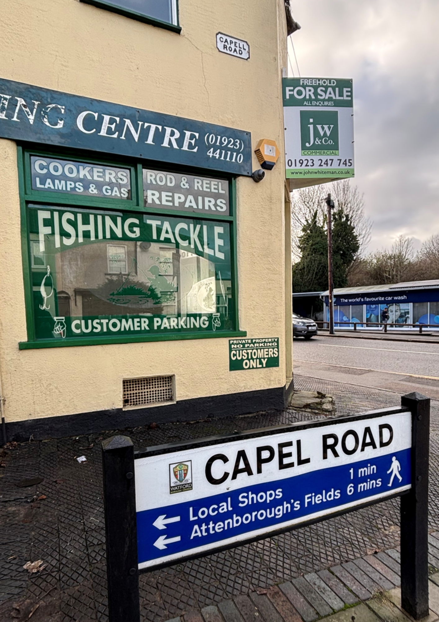
Capel Road (or Capell Road)
Pronounced ‘kay-pul,’ the name of this road refers to the Earls of Essex – aka the Capell family – who owned Cassiobury House and Cassiobury Park until 1922. The 6th Earl of Essex changed the spelling, by royal licence, to Capell. This change is reflected in the difference between the spelling on older, and more modern, street signs at either end of Capel Road.
Cedar Road
We are currently researching the name of this street. If you can help, please contact publicity@oveg.org.
Chalk Hill
At the junction of Pinner Road and Aldenham Road, there was once a chalk pit. This can be seen in the Ordnance Survey map of 1871. Bushey Lime Works was also situated on the other side of the railway line.
Cross Road
We are currently researching the name of this street. If you can help, please contact publicity@oveg.org.
Eastbury Road
Starting at Bushey Arches, Eastbury Road stretches for just less than a mile before becoming Hampermill Lane. Hampermill Lane leads towards the area now known as Eastbury, which covers the area between Moor Park, South Oxhey and Northwood. It was once part of the Manor of Eastbury, dating back to the 13th century when it belonged to the monks of St Albans Abbey. In 1918, the estate passed in to the hands of Lord Ebury who auctioned the entire 3,000 acre manor.
Edinburgh Mews:
A nod to the former Duke of Edinburgh pub that stood on the site until its demolition in the 1960s. Named after Prince Alfred, the Duke of Edinburgh, it was once called the Colliers Arms. Following demolition in the mid-1960s, the site hosted a car showroom before making way for today’s Attenborough Court. Read more about the Duke of Edinburgh pub in our article on the lost pubs of Oxhey Village.
Elm Avenue
There was once a row of elm trees, just south-west of Elm Avenue. The trees were felled due to Dutch elm disease, around the 1970s.
Field End Close
We are currently researching the name of this street. If you can help, please contact publicity@oveg.org.
Field Road
The alignment of Field Road runs at the boundary of what was once ‘Paddock Brick Field,’ so it seems likely this is the origin of the name. See ‘Brick Field Close’ for more more on the brick works.
Firbank Drive
We are currently researching the name of this street. If you can help, please contact publicity@oveg.org.
Grover Road
The Grover family were wine merchants who owned the land on which Grover Road was built in the 1880s. However, they are probably better know for their connections to a local football institution. Their son, Henry Grover, purchased a football acquired permission from the Earl of Essex to host a kickaround with his friends in Cassiobury Park. Henry named his team Watford Rovers; later becoming the Watford Football Club that exists to this day.
Haydon Road
Hayden (or Haydon) family were local landowners in the sixteenth and seventeenth centuries, and at one time owners of The Grove hotel in Watford. Their name was also reflected in the Haydon Arms; a pub based on Upper Paddock Road until its closure in 2001. Read more about the Haydon Arms our article on the lost pubs of Oxhey Village.
Heath Road
While we cannot be certain about the naming of Heath Road, it stands to reason that it refers to Watford Heath, which lies less than a few minutes’ walk away.
Hensby Mews
A small cul-de-sac containing just two properties, Hensby Mews runs alongside Oxhey Village Green. In 2009, the road was named after Bunny Hensby – Oxhey Village Environment Group’s founding member – in recognition of her work for the community. Bunny passed away in 2011.
Horsehaven Mews
Situated on the corner of Bucks Avenue and Sherwoods Road, Horsehaven Mews was built on the site of the former Bucks Meadow Riding School. The development was completed in 2019 following wide-spread local opposition.
King Edward Road
Construction of Kind Edward Road was underway in the early years of the nineteenth century, when King Edward VII was on the throne.
Kingsfield Road and Kingsfield Court
The site on which Kingsfield Road and Kingsfield Court now sits was once a patch of farmland called ‘Kings Field,’ part of Wiggen Hall Farm.
Laurel Close
We are currently researching the name of this street. If you can help, please contact publicity@oveg.org.
Lime Close
A notable former resident of Oxhey Village was Mary Bromet (nee Pownall), a Lancashire-born sculptor who went on to become president of the Society of Women Artists. From 1903 to 1931, she and her husband Alfred Bromet lived in Lime Lodge, a two-storey white home with a spacious studio. Lime Close is built on the site of her home and gardens.
Lower Paddock Road / Upper Paddock Road
Prior to development, the Paddock Road area was a large orchard and subsequently split into building plots. These plots were sold by auction on 19 October 1861 when they were described simply as Paddock Road. A document dated 17 June 1892 refers to what is now Upper Paddock Road as South Paddock Road. On 5 May 1915 it became Upper Paddock Road within the Parish of Bushey. The first known document to bear the modern name of Upper Paddock Road is dated 15 February 1929.
Lowson Road
We are currently researching the name of this street. If you can help, please contact publicity@oveg.org.
Maxwell Rise
The land on which Maxwell Rise was built was acquired by a builder – named Mr Maxwell – who proceeded to construct 13 houses. (History sheet 15 recollections of oxhey village Dora Duncan)
Oxhey Avenue
Starting at Pinner Road – close to the junction of Grover Road – Oxhey Avenue continues uphill to Watford Heath. The section of the road between what is now Lime Close, and the junction with Pinner Road, was once named Oxhey Street. The construction of Oxhey Avenue was said to be much to the annoyance of Mary Bromet (nee Pownall) – a locally-based sculptor after whom Bromet School is named – due to it ‘curtailing her view of Oxhey Woods.’
Oxhey Road
Originally a part of Oxhey Lane, Oxhey Road was developed and gained its current name sometime after the construction of the railway.
Paddock Close
A newer street in the area, Paddock Close sits close to Lower Paddock Road.
Parkside
The origin of this street name is quite straightforward; Parkside sits on the opposite side of Eastbury Road from Oxhey Park.
Pinner Road
Running for around 0.5 miles, Pinner Road is the main road through the centre of Oxhey Village. It begins at Bushey Arches and continues just past Watford Heath where it becomes Oxhey Lane.
Rowley Close
We are currently researching the name of this street. If you can help, please contact publicity@oveg.org.
Sheridan Road
We are currently researching the name of this street. If you can help, please contact publicity@oveg.org.
Sherwoods Road
The name Sherwood is a corruption of ‘shire wood,’ with shire being a medieval term for land owned by an abbey, or within an ecclesiastical jurisdiction. In this instance, the name refers to an area of woodland, just south of Oxhey Village, called Sherwoods Wood.
Talbot Avenue
We are currently researching the name of this street. If you can help, please contact publicity@oveg.org.
Vera Court
We are currently researching the name of this street. If you can help, please contact publicity@oveg.org.
Villiers Road
Nearby Villiers Road commemorates the family name of the Earls of Clarendon, who used to reside at The Grove. This connection is also reflected in the Villiers Arms pub.
Watford Heath
The heath pre-exists Oxhey Village by many centuries. The area now known as Watford Heath is a survivor of the common pasture, a feature of the open field system of agriculture. It is thought to have once been known as Goose Green. Until 1880, the heath was owned by the Lord of the Manor of Wiggenhall, also known as ‘Oxhey Walrond’. The land was purchased by Watford’s council in 1932, and later registered as common land on 31 July 1973.
Warneford Place
This small cul-de-sac, just off King Edward Road commemorates the exploits of Flt Sub Lt Reginald ‘Rex’ Warneford. The World War One pilot – dubbed ‘Reckless Rex’ was lauded as a national hero, after becoming the first airman to destroy a German Zeppelin in mid-air. Sadly, he died just ten days later. His association with Oxhey Village arose from his frequent stays at his aunt’s house, throughout the course of his relatively short life.
Wilcot Avenue and Wilcot Close
We are currently researching the name of this street. If you can help, please contact publicity@oveg.org.
Ye Corner
Less of a street, more of a rounded terrace, Ye Corner is a mixture of residential and commercial property on the corner of Chalk Hill and Aldenham Road. The title bears no relation to the history of the area; it is a fake antiquarianism, chosen by the builder who developed the site in 1907.
You must be logged in to post a comment.